| Nearby Places |
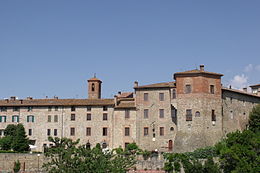
 Municipality of Piegaro Municipality of Piegaro |
[Top] |
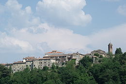
Piegaro is a comune (municipality) in the Province of Perugia in the Italian region Umbria, located about 30 km southwest of Perugia. Piegaro borders the following municipalities: Città della Pieve, Marsciano, Montegabbione, Monteleone d'Orvieto, Paciano, Panicale, Perugia, San Venanzo.
|
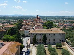
| Panicale |
[Top] |
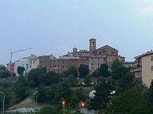
Panicale is a comune (municipality) in the Province of Perugia in the Italian region Umbria, located about 25 km southwest of Perugia. As of 31 December 2012, it had a population of 5,669 and an area of 78.8 km².
The municipality of Panicale contains the frazioni (subdivisions, mainly villages and hamlets) Tavernelle, Colle San Paolo, Missiano, Casalini, Colle Calzolaro, Macereto, Mongiovino, Montale, Colgiordano, Gioveto, and Migliaiolo.
Panicale borders the following municipalities: Castiglione del Lago, Magione, Paciano, Perugia, Piegaro.
|
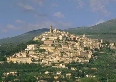
| Paciano |
[Top] |
Paciano is a comune (municipality) in the Province of Perugia in the Italian region Umbria, located about 30 km southwest of Perugia. As of 31 December 2004, it had a population of 974 and an area of 16.8 km².[1]
Paciano borders the following municipalities: Castiglione del Lago, Città della Pieve, Panicale, Piegaro.
|
| Castiglione del Lago |
[Top] |
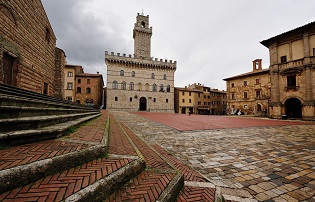
Castiglione del Lago is a town in the Province of Perugia of Umbria (central Italy), on the southwest corner of Lake Trasimeno. Orvieto is 59 km (37 mi) south, Chiusi is 21 km (13 mi) to the south west, Arezzo is 56 km (35 mi) to the north west, Cortona is 21 km (13 mi) to the north and Perugia is 47 km (29 mi) to the south east.
|
| Scarzuola (Montegiove) |
[Top] |
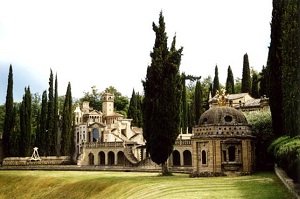
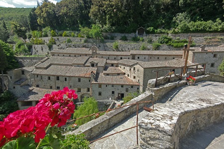
Scarzuola is a surreal construction designed by Tomaso Buzzi, architect, artist and man of culture among the most important of the 900. It rises Montegiove, in the municipality of Montegabbione ( Tr). Is built on the same site of a monastery founded by St. Francis of '200. Tomaso Buzzi buys in 1957 and builds on its surroundings an ideal city, tracing a path symbolic neo-Enlightenment refers to esoteric knowledge and his insights . Scarzuola consists of buildings grouped into seven scenes theatrical metaphor for the life of each. At his death, in 1981 , the property passed to his nephew, Marco Solari who continues to build, using the projects left by his uncle, is now virtually complete. Tomaso Buzzi is eminent character of Italian culture in the late twenties he founded the magazine Domus with Gio Ponti, where he wrote until 1937 , in 1932 he is artistic director of Venini in Venice at that time participated in several editions of the Biennale with his creations, always in the thirties designing some districts of Milan. In 1936, after the promulgation of racial laws, dissociates itself from the regime and began a path of professional independence, becomes the greatest architect of the Italian nobility and the upper middle class. Work abroad and overseas, in the early fifties was commissioned by the Italian government to restore the embassies of North Africa and the Middle East. The current owner, Marco Solari, is the grandson of Buzzi. Came into possession of the place after 1981, he decided to settle down to finish the work by the architect designs let him in inheritance. Can not add more, relative to the external structures , because the work is constrained by the Superintendent from the seventies. So Scarzuola, based on the first poem illustrated Italian " Hypnerotomachia Poliphili ," is nothing more than an initiatory journey within ourselves where we can meet places, in the form of theatrical scenes, a metaphor for the life of us all, in short, a journey into soul, not through the place created by the fertile mind of Buzzi. Inside the courtyard of the monastery is visible access to a series of 14 tables in plastic terracotta depicting the Stations of the Cross by Fra Petrus de Scarsellis and Father Nicolai de Urbe Veteri (1735 ). In addition, the church was restored and refurbished by Marco Solari dominus of the site, contains frescoes (since the thirteenth century) Of considerable historical importance and seventeenth-century furnishings, also many of the nobles of the place (and Bulgarelli Misciattelli ) protectors of the Franciscan order, there to rest since the year 1290. Finally, the beautiful garden, as well as being itself an integral part of the esoteric path like sculpture, contains a number of plant species and a large number of cypress trees. |
| Città della Pieve |
[Top] |
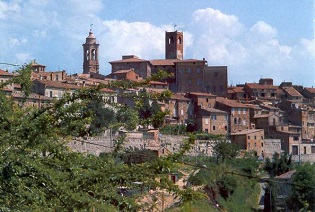
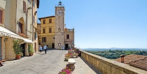
Città della Pieve is a comune (municipality) in the Province of Perugia in the Italian region Umbria, located about 50 km (31 mi) southwest of Perugia. As of 31 December 2004, it had a population of 7,366 and an area of 111.5 km2 (43 sq mi).
Etruscan tombs have been found in the neighbourhood, but it is not certain that the present town stands on an ancient site. It was the birthplace of the painters Pietro Vannucci (Perugino), possessing several of his works, and Niccolò Circignani.
Città della Pieve borders the following municipalities: Allerona, Castiglione del Lago, Cetona, Chiusi, Fabro, Monteleone d'Orvieto, Paciano, Piegaro, San Casciano dei Bagni.
|
| Infiorata of Città della Pieve |
[Top] |
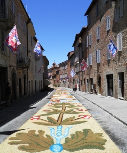
As a tribute to their Patron Saint Aloysius Gonzaga, the Contrada of the Terziere Casalino make annually a unique floral display. This event, the most important that the city offers to its visitors, traditionally marks the beginning of Pieve City summer events. The floral display is also music and entertainment, in fact, in the Saturday night and Sunday afternoon visitors are accompanied along the way by musical harmonies. In the magical nights of the summer solstice, in a blend of art, spirituality, history and ancient traditions, the Contrada of the Terziere realize that the next morning is the incomparable spectacle of the "Infiorata".
Link: http://www.terzierecasalino.it/L'infiorata.html |
| Perugia |
[Top] |
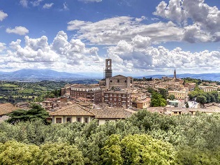
Perugia (Italian pronunciation: [peˈruːdʒa] ( listen); (Latin: Perusia) is the capital city of the region of Umbria in central Italy, crossed by the river Tiber. The city is also the capital of the province of Perugia. Perugia is located about 164 kilometres (102 miles) north of Rome, and 148 km (92 miles) south-east of Florence. It covers a high hilltop and part of the valleys around the area. The region of Umbria is bordered by Tuscany, Lazio and Marche.
The history of Perugia goes back to the Etruscan period. Perugia was one of the main Etruscan cities. The city is also known as the universities town, with the University of Perugia founded in 1308 (about 34,000 students), the University for Foreigners (5,000 students), and some smaller colleges such the Academy of Fine Arts "Pietro Vannucci" (Italian: Accademia di Belle Arti "Pietro Vannucci") public athenaeum founded on 1573, the Perugia University Institute of Linguistic Mediation for translators and interpreters, the Music Conservatory of Perugia, founded on 1788, and others Institutes. There are annual festivals and events: the Eurochocolate Festival (October), the Umbria Jazz Festival (July), and the International Journalism Festival (in April).
Perugia is a well-known cultural and artistic centre of Italy. The famous painter Pietro Vannucci, nicknamed Perugino, was a native of Città della Pieve near Perugia. He decorated the local Sala del Cambio with a beautiful series of frescoes; eight of his pictures can also be admired in the National Gallery of Umbria. Perugino was the teacher of Raphael, the great Renaissance artist who produced five paintings in Perugia (today no longer in the city) and one fresco.Another famous painter, Pinturicchio, lived in Perugia. Galeazzo Alessi is the most famous architect from Perugia. The city symbol is the griffin, which can be seen in the form of plaques and statues on buildings around the city.
|
| Assisi |
[Top] |
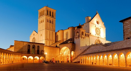
Assisi (Italian pronunciation: [asˈsiːzi], from the Latin: Asisium) is a town and comune of Italy in the province of Perugia in the Umbria region, on the western flank of Monte Subasio.
It was the birthplace of St. Francis, who founded the Franciscan religious order in the town in 1208, and St. Clare (Chiara d'Offreducci), the founder of the Poor Sisters, which later became the Order of Poor Clares after her death. The 19th-century Saint Gabriel of Our Lady of Sorrows was also born in Assisi.
|
| Spello |
[Top] |
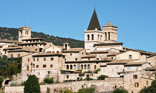
Spello (in Antiquity: Hispellum) is an ancient town and comune (township) of Italy, in the province of Perugia in east central Umbria, on the lower southern flank of Mt. Subasio. It is 6 km (4 mi) NNW of Foligno and 10 km (6 mi) SSE of Assisi.
The old walled town lies on a regularly NW-SE sloping ridge that eventually meets the plain. From the top of the ridge, Spello commands a good view of the Umbrian plain towards Perugia; at the bottom of the ridge, the town spills out of its walls into a small modern section (or Borgo) served by the rail line from Rome to Florence via Perugia.
|
| Trevi |
[Top] |
Trevi (Latin: Trebiae) is an ancient town and comune in Umbria, Italy, on the lower flank of Monte Serano overlooking the wide plain of the Clitunno river system. It is 10 km (6 mi) SSE of Foligno and 20 km (12 mi) north of Spoleto.
The population of the comune was c. 8,000 in 2004, with the town proper accounting for about half of that; the rest lives in the frazioni of Borgo, Bovara, Cannaiola, Coste, Pigge, Manciano, Matigge, Parrano, Picciche, San Lorenzo and Santa Maria in Valle. The historical subdivisions of Trevi proper are the terzieri of Castello, Matiggia e Piano; they come into play only for the Palio.
Most of the town, densely inhabited and of decidedly medieval aspect, lies on sharply sloping terrain, only the very center being more or less flat. It commands one of the best views in Umbria, extending over 50 km (30 mi) in most westerly directions. Trevi is served by the main rail line from Rome to Ancona as well as the line from Florence to Rome via Perugia.
|
| Spoleto |
[Top] |
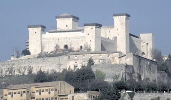
Spoleto (Latin Spoletium) is an ancient city in the Italian province of Perugia in east central Umbria on a foothill of the Apennines. It is 20 km (12 mi) S. of Trevi, 29 km (18 mi) N. of Terni, 63 km (39 mi) SE of Perugia; 212 km (132 mi) SE of Florence; and 126 km (78 mi) N of Rome.
|
| Orvieto |
[Top] |
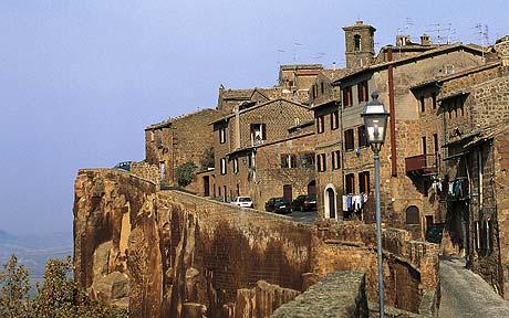
Orvieto is a city and comune in Province of Terni, southwestern Umbria, Italy situated on the flat summit of a large butte of volcanic tuff. The site of the city is among the most dramatic in Europe, rising above the almost-vertical faces of tuff cliffs that are completed by defensive walls built of the same stone called Tufa.
|
| Civita di Bagnoregio (La città che muore) |
[Top] |
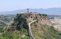
Civita is a fraction of the municipality of Bagnoregio famous for being called "The dying city."
Located in an isolated position, is only accessible via a pedestrian bridge in reinforced concrete built in 1965. The bridge can be crossed only on foot, but recently the town of Bagnoregio, meeting the needs of those who live and/or work in this place, has issued a circular stating that, at certain times, residents and authorized persons can cross the bridge at the edge of cycles and motorcycles. The cause of his isolation is the gradual erosion of the hill and the surrounding valley, which gave rise to the typical forms of gullies and that continues today, threatening to wipe out the village, this is also called "the dying city" or, more rarely, "the dying town".
In the village now live twelve people. |
| Chianciano Terme |
[Top] |
Chianciano Terme is a comune (municipality) in the Province of Siena in the Italian region Tuscany, located about 90 km southeast of Florence and about 50 km southeast of Siena. It is located between the Valdichiana and the Val d'Orcia.
Chianciano Terme borders the following municipalities: Chiusi, Montepulciano, Pienza, Sarteano.
|
| Montepulciano |
[Top] |
Montepulciano is a medieval and Renaissance hill town and comune in the Italian province of Siena in southern Tuscany. It sits high on a (605 metres (1,985 feet)) limestone ridge, 13 kilometres (8 miles) E of Pienza, 70 km (43 miles) SE of Siena, 124 km (77 miles) SE of Florence, and 186 km (116 miles) north of Rome by car.
Montepulciano is a major producer of food and drink. Renowned for its pork, cheese, "pici" pasta, lentils, and honey, it is known world-wide for its wine. Connoisseurs consider its Vino Nobile, which should not be confused with varietal wine merely made from the Montepulciano grape, among Italy's best.
|
| Pienza |
[Top] |
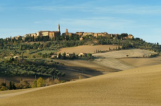
Pienza, a town and comune in the province of Siena, in the Val d'Orcia in Tuscany (central Italy), between the towns of Montepulciano and Montalcino, is the "touchstone of Renaissance urbanism."
In 1996, UNESCO declared the town a World Heritage Site, and in 2004 the entire valley, the Val d'Orcia, was included on the list of UNESCO's World Cultural Landscapes.
|
| Cortona |
[Top] |
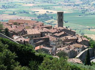
Cortona is a town and comune in the province of Arezzo, in Tuscany, Italy. It is the main cultural and artistic center of the Val di Chiana after Arezzo.
Originally an Umbrian city, it was conquered and enlarged by the Etruscans, who called it Curtun. Cortona eventually became a Roman colony under the name Corito. The origin-legends and ancient names of Cortona are described by George Dennis. In the final stages of the Gothic War (535–554), Cortona was sacked and destroyed.
Cortona became a Ghibellinian city state in the 13th century, with its own currency. From 1325 to 1409 the Ranieri-Casali family successfully ruled the town. After being conquered by Ladislaus of Naples in 1409, Cortona was sold to the Medici in 1411. In 1737, the senior branch of the Medici line went extinct and Cortona came under the authority of the House of Lorraine. Following the Italian Wars of Independence, Tuscany — Cortona included — became part of the Kingdom of Italy.
|
| St. Francis Cells |
[Top] |
To highlight, as quaint place to visit, the convent "Cells" of St. Francis...
The hermitage St. Francis Cells is nestled among the natural caves of Monte Sant'Egidio and is a secluded spot in the woods, near a watercourse. The nature around is beautiful and promotes his silence and contemplation. The magnificent landscape that you can enjoy is a great invitation to praise the Lord. The Hermitage is the first monastery built by St. Francis of Assisi (1211), and was inhabited by him even after receiving the stigmata. In the valley below is the small town of Cortona, in the province of Arezzo. The complex is built so as to follow the natural course of the territory. Cells and other rooms of the Convent, in fact, are located on the valley slopes terraced, stone bridges while creating the connection between the premises. The monastery was visited, among others, also from St. Anthony of Padua, Brother Elias, from Blessed Guido and St. Bonaventure. Since 1537, and is inhabited by the Capuchin Franciscan friars who have chosen until 1988, as a place of apprenticeship for young people eager to follow in the footsteps of St. Francis. Even today you can see the little cell of the Oratory of St. Francis and his first companions. Brother Elias, by mandate of Pope Gregory IX, who had sanctified San Francisco a year and a half after his death, he prepared the grave solemn enriched by the two basilicas above. Brother Elias created with stones from the caves, a small oratory, combined with old dormitory for the monks. He left intact the cell occupied by St. Francis, creating solid walls, built over eight small rooms, where it enters a bed, a wall mounted ironing table and a chair. This was the ideal of Hermitage described and wanted by St. Francis himself, as a contemplative expression of his order.
How to reach
Locality Le Celle, 73 Cortona, Arezzo
By train: railway station in Florence, then continue with the SITA bus to Tosi.
By car: A1 exit Firenze-Sud, then take the SS 57 and SS 70 Pontassieve up to Pelago.
hospitality
The monastery can accommodate within young people in vocational research with a commitment to participate in the entire life of the fraternity.
Next to the convent are two "houses" of a total of 40 places for self-managed groups.
Religious activities
The fraternity of "Cells" offers to priests and religious, the opportunity to spend a period in solitary prayer (From one week to one month) in a small chapel, called St. Michael, situated on the flat top of the pad that overlooks the wooded Convent.
Suggested web sites:
Official Site: www.lecelle.it |
| Chiusi |
[Top] |
Chiusi (Etruscan: Clevsin; Umbrian: Camars; Ancient Greek: Klysion, Κλύσιον; Latin: Clusium) is a town and comune in province of Siena, Tuscany, Italy.
It was one of the more powerful among the Etruscan 12‑city confederation. Chiusi went into the Roman orbit in the 3rd century BC and took part to the Social War.
In 540 AD it was occupied by the Ostrogoths and was later seat of Lombard duchy. From the 11th century it was under the rule of the local bishop, and was later contended by Orvieto and, from 1231, Siena, belonging to the latter until 1556, when it was annexed to the Grand duchy of Tuscany.
|
| San Quirico d'Orcia |
[Top] |
San Quirico d'Orcia is a comune (municipality) of c. 2,500 inhabitants in the Province of Siena in the Italian region Tuscany, located about 80 km southeast of Florence and about 35 km southeast of Siena inside the Valdorcia landscape. It is named in honor of Saint Quiricus.
San Quirico d'Orcia borders the following municipalities: Castiglione d'Orcia, Montalcino, Pienza, San Giovanni d'Asso.
|
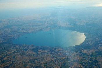
| Il Lago Trasimeno |
[Top] |
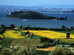
Trasimeno Lake (Italian: Lago Trasimeno, Italian pronunciation: [ˌlaːɡo traziˈmɛːno]; Latin: Trasumennus; Etruscan Tarśmina[1]), also referred to as Trasimene or Thrasimene in English, is the largest lake on the Italian peninsula, part of the province of Perugia, in the Umbria region. The Lake is located in the south of the Po River and to the north of the nearby Tiber River, with a surface area of 128 km2 (49.4 sq mi), slightly less than Lake Como. No major river flows directly into or out of Lake Trasimeno and the water level fluctuates significantly according to rainfall levels and the seasonal demands from the towns, villages and farms near the shore.
Locality near Trasimeno Lake
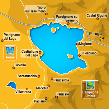
Towns that overlook the shores of the lake:
San Feliciano
Monte del Lago
Torricella
Passignano sul Trasimeno
Tuoro sul Trasimeno
Borghetto
Castiglione del Lago
Panicarola
Sant'Arcangelo
San Savino
They are part of the district of Trasimeno Lake:
Castiglione del Lago
Città della Pieve
Magione
Paciano
Panicale
Passignano sul Trasimeno
Piegaro
Tuoro sul Trasimeno |
| Lago di Bolsena |
[Top] |
Bolsena Lake (Italian: Lago di Bolsena) is a crater lake of central Italy, of volcanic origin, which was formed starting 370,000 years ago following the collapse of a caldera of the Vulsini volcanic complex into a deep aquifer. Roman historic records indicate activity of the Vulsini volcano occurred as recently as 104 BC, since when it has been dormant. The two islands in the southern part of the lake were formed by underwater eruptions following the initial collapse of the caldera.
The lake is supplied entirely from the aquifer, rainfall and runoff, with one outlet at the southern end. A sewage treatment plant filters most of the raw sewage from the surrounding communities. Constructed in 1996, it features pipelines transporting the sewage from every major community around the lake to the treatment plant on the Marta River; that is, no effluents enter the lake.[4] Fertilizers are a second source of contamination. However, the chemical content of the lake is monitored at several stations around it.
Lying within the northern part of the province of Viterbo that is called Alto Lazio ("Upper Latium") or Tuscia, the lake has a long historic tradition. The Romans called it Lacus Volsinii, adapting the Etruscan name, Velzna, of the last Etruscan city to hold out against Rome, which was translocated after 264 BC, and its original location today has not been securely identified. The lake is bordered on one side by updated forms of the Roman consular road Via Cassia. In addition to the historic sites of all periods, Bolsena Lake is currently surrounded by numerous tourist establishments, largely for camping, agrotourism and bed and breakfasts.
One third of the lake was donated to the Church by the noble family Alberici of Orvieto. In recognition of the donation the Alberici family was honored with a ceremony three times a year performed by the Bishop of Orvieto.
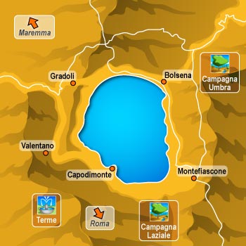
Towns that overlook the shores of the lake:
Bolsena
Montefiascone
Marta
Capodimonte
Valentano
Gradoli
Grotte di Castro
San Lorenzo Nuovo
|
| The Marmore's Falls |
[Top] |
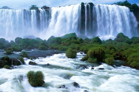
The Cascata delle Marmore (Marmore's Falls) is a man-made waterfall created by the ancient Romans. Its total height is 165 m (541 feet), making it one of the tallest in Italy and the tallest man-made waterfall in the world. Of its 3 sections, the top one is the tallest, at 83 m (272 feet).
It is located 7.7 km from Terni, a provincial capital of the Italian region of Umbria.
Its source is a portion of the waters of the river Velino (the rest of the river flows into a hydroelectric power plant), after flowing through Piediluco lake near the community of Marmore. It pours into the valley below formed by the river Nera. Its flow is turned on and off according to a published schedule, to satisfy the needs of tourists and the power company alike. Tourists try to be there the moment the gates are opened to see the powerful rush of water.
|
|
|